
Scan the QR code and open PeakVisor on your phone
Ostrovnoy zakaznik has 15 named peaks. The highest is Stokap at 1,634 m. Other notable peaks include Stokap (Vershina), Gora Burevestnik and Berutarube.
Feel like going to an exotic place that will test your endurance and willpower? How about the Far East of Russia, the Kuril Islands that form the border between the wild Pacific Ocean and the nonetheless human-unfriendly Sea of Okhotsk?
The Iturup Island Sanctuary, the name in Russian is Ostrovnoy, is an amazing natural monument of the Sakhalin Region in the Russian Far East. Majestic volcanoes with menacingly smoking gas jets neighbor here with picturesque serene waterfalls, clear rivers, beautiful coastal rocks and bays, unusual flora and strange sea inhabitants. When you come here, it is as if you find yourself on a desert island where you can be alone with yourself and with nature.
The Iturup Island (Ostrovnoy) State Sanctuary was officially established in 1988. It occupies 80 thousand hectares and is located in the southern part of Iturup Island. The island itself is part of the Kuril Islands of the Sakhalin Region. It is supposed to be annexed to the Kuril Nature Reserve in the near future, which will make it possible to create a unified environmental scientific and educational complex consisting of the neighboring territories of the Kuril Reserve (on Kunashir island), the Malye Kuril Reserve (on Shikotan island) and the Ostrovnoy reserve (on Iturup island). Scientists, environmentalists and local residents have put forward an initiative to grant the united reserve federal status.
The part of Iturup Island, where the sanctuary is located, has a mountainous relief. It is a beautiful home of volcanoes (Atsonupuri, Berutarube), ridges (Bogatyr, Bezvodny, Dugovoy), isthmuses (Dobry, Roka, Dozorny). The sea coast is represented by strips of black sandy beaches with towering cliffs. The coves are very picturesque. The coasts are mostly high and there are not many convenient places for mooring ships.
Of the large lakes, we can single out Krasivoye (Beautiful), Dobroe (Kind), and Lesozavodskoye (Forestry) lakes. A large number of small rivers and creeks are teeming with fish. Their waters are clean but not during the salmon spawning period and many of them carry fresh water suitable for drinking. And what waterfalls are here! There are plenty of them here. You'll know when you're approaching a waterfall by the noise of water falling from a height and the wall of finely dispersed droplets with rainbows popping here and there.
Fabulous beauty of mixed forests (mostly spruce) interspersed with thickets of bamboo (sasa) are a feast for the eyes. When you see them from a height, they can look like picturesque meadows. The land is rich in mushrooms and berries. There are specimens of Sakhalin mushrooms the size of a frying pan. It is said that the flavor of this mushroom is in no way inferior to that of the white mushroom.
Six species of land mammals, of which one is included in the Red Book of Sakhalin Region, 217 bird species, of which 22 are included in the Red Book of the Russian Federation and 40 in the Red Book of Sakhalin Region are registered in the Iturup Island Sanctuary.
Brown bear, fox, sable and European mink inhabit here. Lake Dobroe is home to the largest population of Sakhalin taimen (striped flounder), which is included in the Red Books of Russia and the Sakhalin Region.
The peculiarity of the fauna of Iturup Island is clear predominance of predators over other animals. Walking around the island, one can easily encounter a bear or a fox. Predators do not always find enough food here, so you can often see unusually skinny bears, which makes you want to feed it. But you must not do that on any account! And a fox in search of food could sneak into the tent. Therefore, you must be vigilant.
A few kilometers from the cordon on the coastal cliffs there is a rookery of insula seals-calves. Because of the small number of seals, this species is included in the Red Book of Russia and the Red Book of the International Union for Conservation of Nature. Not far from the seals rookery, there is a bird seashore colony.
The climate in this region is maritime monsoon, humid, with very strong long-lasting winds and an abundance of fog. Clear weather is quite a rarity in Iturup. The clouds are usually low which makes the skies overcast most of the time. By the way, the Okhotsk Sea coast features much less fog and more sunny days than the Pacific coast, which affects the presence of a richer and more diverse flora and fauna. Winters on Iturup are mild and warm, characterized by frequent snowfalls and thaws. The coldest month of winter is January with average monthly temperatures of -5C (41F). Summers are cool, with August being the warmest of the summer months due to high humidity. Its average temperature is about 14 - 15 C (57 - 59 F). Strong cyclones (typhoons) are common during the fall and summer seasons
The Iturup Island Sanctuary is a true gateway to the natural riches of the island. Here you can feel like a volcano conqueror, you can climb to the volcano tops and overcome all the obstacles on the way to the majestic craters, admire the landscapes of the area and have a glimpse of the elusive representatives of the island's animal world.
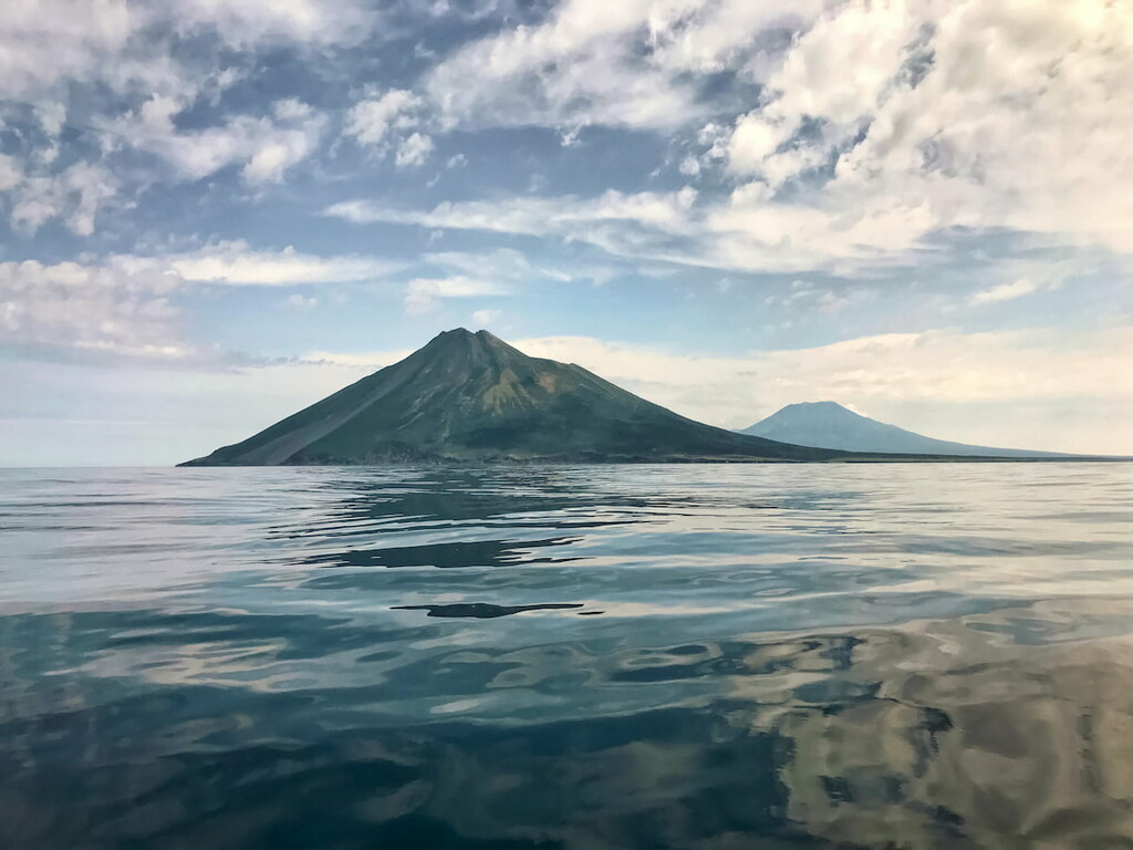
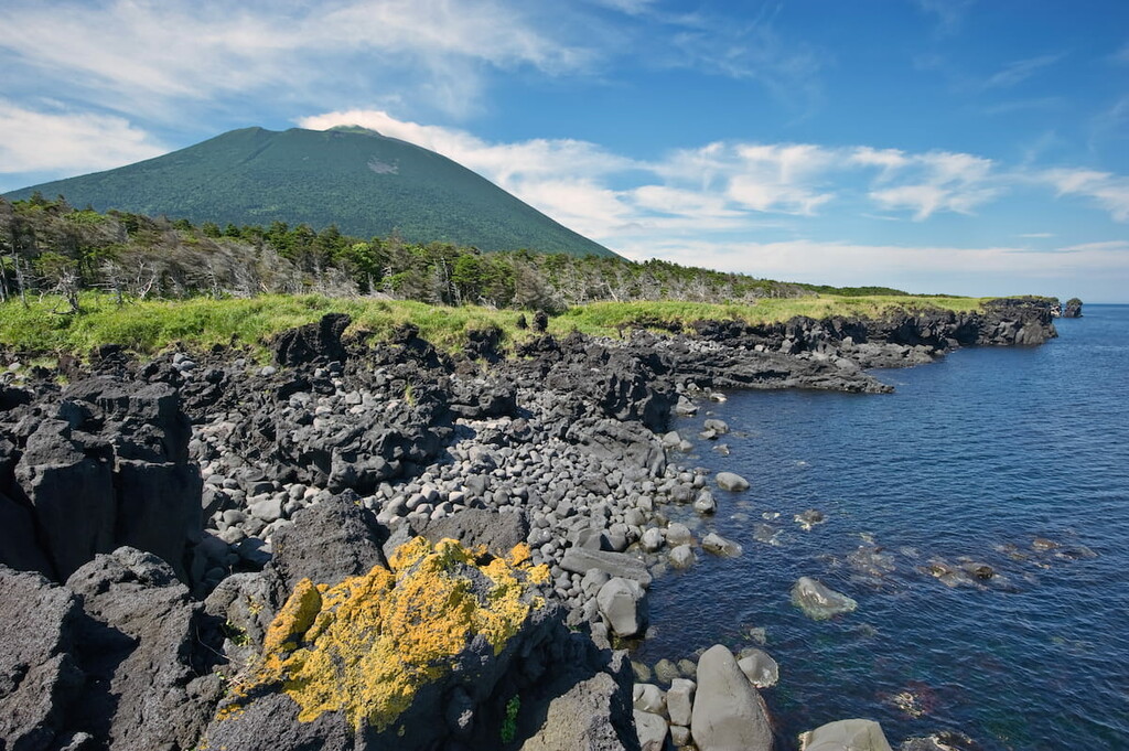
Due to its regular perfect shape, Atsonupuri Volcano (1,205m) is considered one of the most beautiful active volcanoes on the island. It cuts deep into the Sea of Okhotsk and is only connected to the island by a narrow stretch of land.
Atsonupuri Volcano has a somma volcano – the remnant of an older edifice – whose rim is exposed at 900m a.s.l. on the south-eastern side. The predecessor of Atsonupuri was active in the late Pleistocene or early Holocene and once formed an island up to about 1.5 km high, which was later connected to Iturup Island by sediments.
An important normal fault cuts through the north-western side of the somma of Atsonupuri, which is also known as Etorofu-Atosanupuri. Its 2-km-wide caldera was largely filled and overtopped by a central cone that forms the present-day summit. Atsonupuri is also called Fuji Etorofu by the Japanese people.
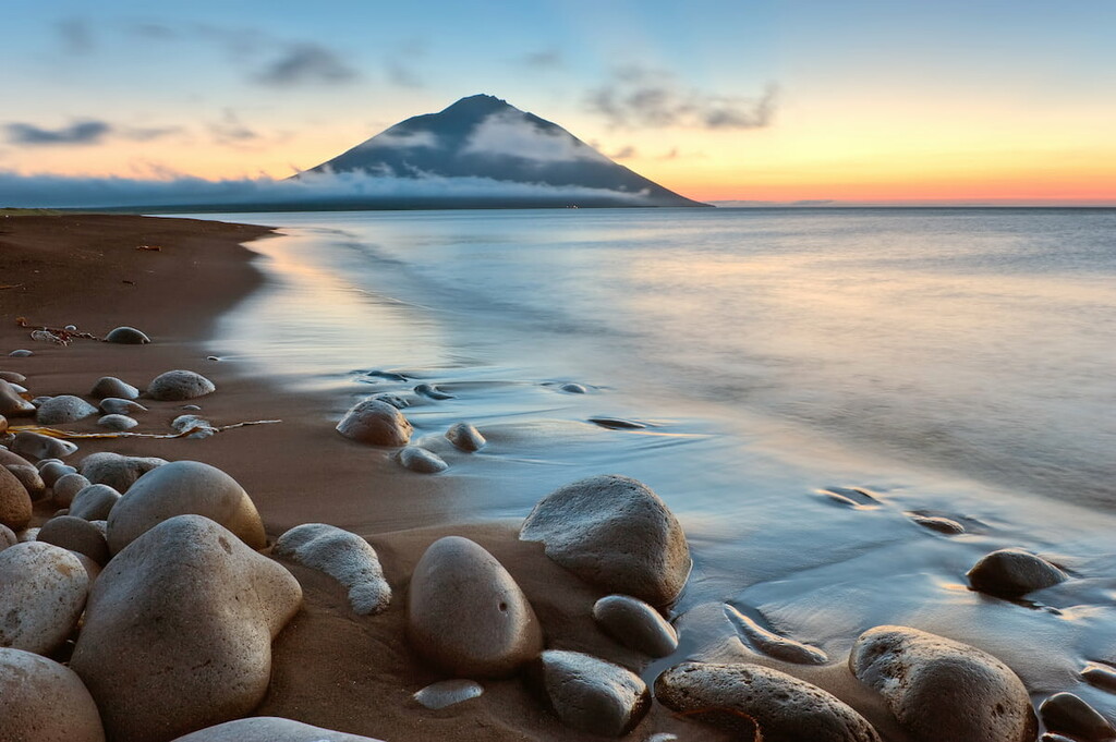
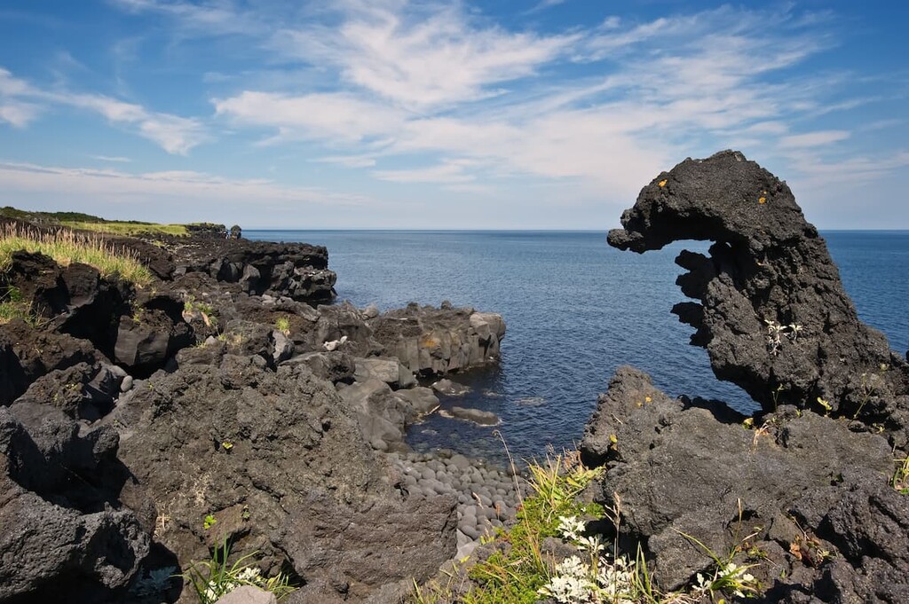
The last eruption happened in 1932. The scorching-hot lava streams rushed into the sea and froze in various bizarre forms as they came into contact with the cold water.
On the way to the top of the volcano you will have to work your way through bamboo thickets in some places. From above, you can see the cones of volcanoes on Iturup Island and neighboring Kunashir Island with its inaccessible Rurui volcano and majestic Tyatya volcano which seem to be floating above the clouds. It is as if you are in a fairy-tale land up above the clouds, Heaven Revisited indeed.
There is a bay with a funny name - the Bay of Good Beginnings – not far from Atsonupuri. The bay was first described by the sailors of Juno and Mayhap (the name in Russian is Avos) ships in 1807 and the name Good Beginnings commemorated the eviction of the Japanese from the island and the establishment of Russian settlements. The bay has a perfect 20-km long beach with black volcanic sand and mind-blowing views of Atsonupuri Volcano.
In the olden times, there were large settlements on the nearby Tikhaya (Quiet) River, which carries its waters into the bay. Today, however, they are abandoned.
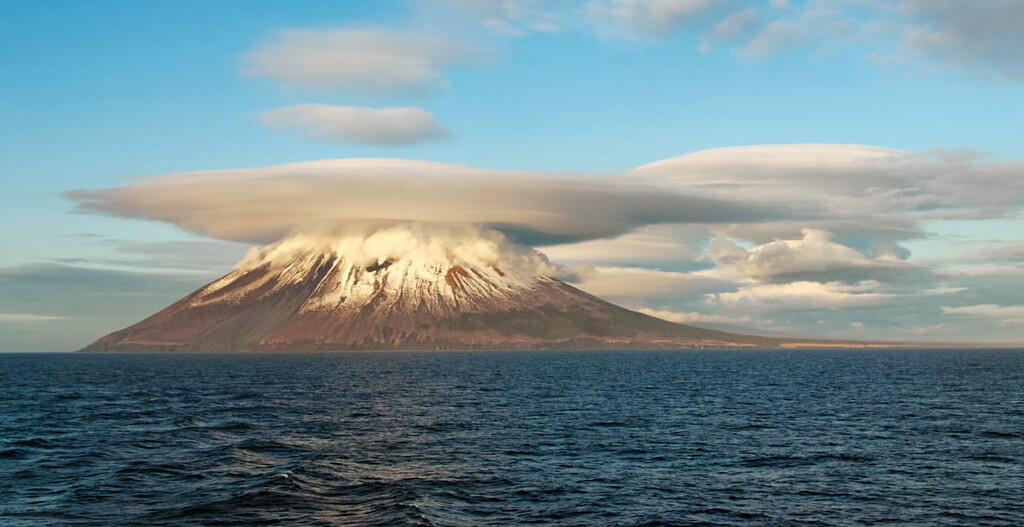
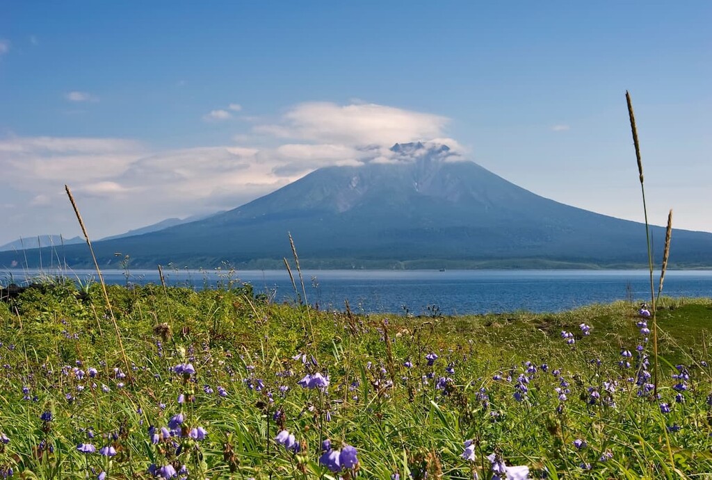
The nearest neighbor of Atsonupuri is a monumental volcano Stokap Volcano (1,634m). It looks down on all the other attractions of the island. This is the highest point of the island of Iturup. The slopes of the volcano are covered with lava streams going down to the sea. At present, scientists record its weak activity on its eastern slope.
Ash clouds, ash falls, red-hot avalanches, and lahars (volcanic mudflows) associated with explosive eruptions of the volcano pose a potential hazard. The volcano poses a substantial threat to international and local airlines passing in the Kuril Region because the height of its ash emissions can reach up to 10 km a.s.l., ash plumes and clouds can extend for hundreds of kilometers from the volcano in different directions. Stokap looks like another Eyjafjallajökull whose eruptions in 2010 brought European air travel to an epic standstill. In addition, lava flows may outpour onto the slopes of the volcano and its adjacent neighborhoods.
The Iturup Island Sanctuary begins per se at the Rikorda Cape (the southern tip of the island), a steep cliff that is actually a spur of Berutarube Volcano (1,223 m). The volcano’s western slope enjoys active fumarole and thermal phenomena. This active volcano has a cone shape with the base diameter of about 11 km and several summit craters. The slopes are gentle, and a caldera of about 2.5 km in size is formed in its upper part.
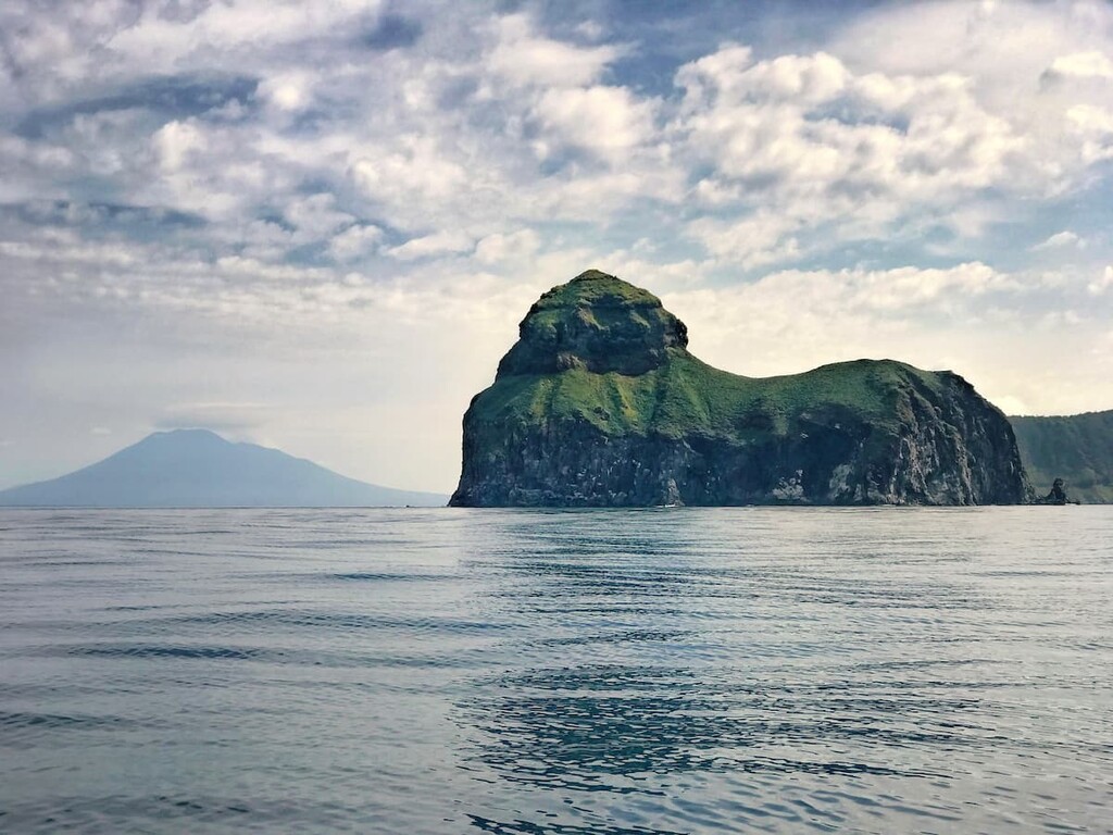
The Lion's Mouth Bay and the Kamen-Lev (Stone Lion) Island is another wonder of the Sanctuary. First of all, the Lion's Mouth is a volcano located in the southwestern part of Iturup Island. An eruption which happened in bygone times resulted in the formation of a caldera. It is about 9 km in diameter and about 1 km deep. After the summit collapse, the caldera of the volcano filled with waters of the Sea of Okhotsk, thus forming the Lion's Mouth Bay which is now about 5 km wide. From a bird's eye view, it really resembles a lion's mouth. On both sides of the bay, there are Fang and Jaw peninsulas as if guarding it.
There are two entrances to the bay, they are separated by a fragment of the edge of the caldera rising 162m above the sea surface. Today it is an island called Kamen-Lev or Stone Lion. The silhouette of the island resembles a lying lion and is similar in shape to the Egyptian Sphinx. If you are lucky with the weather and manage to land on this island, you can observe the rookery of the larga seals and sea lions nearby. You may also be lucky to spot some sea otters.
The ancient volcanic Urbich caldera is located in the northern part of the Rokka Massif. It is separated from the Sea of Okhotsk by a mountain chain. Numerous waterfalls descend from the eastern slope of the caldera and at the bottom of the caldera is Lake Beautiful, 48m deep and almost 6 sq.km. in area. The waters of the lake are the only place on Iturup Island where the blue-backed salmon (Orcorhynchus nerka) spawns. Every year the sockeye comes here, overcoming all the possible rapids of the Urumpet River which connects the lake with the Pacific Ocean.
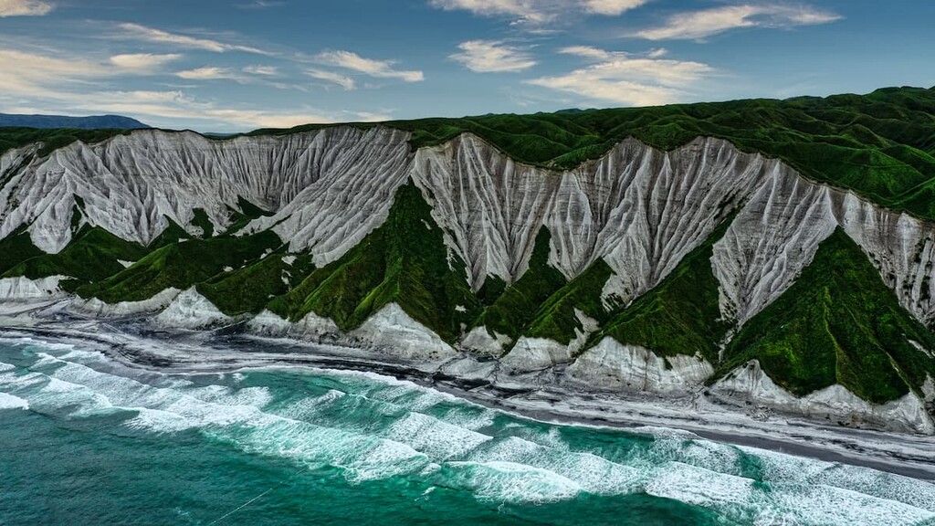
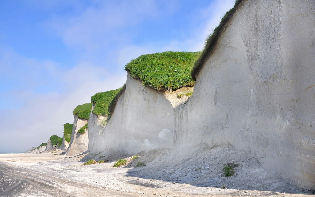
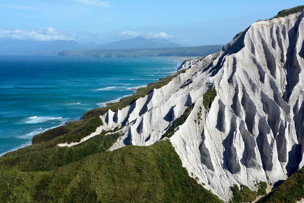
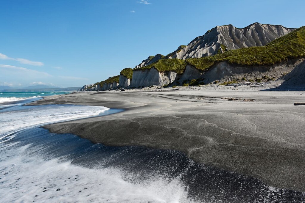
The White Cliffs are a fascinating sight and an iconic landmark of Iturup. The cliffs stretch along the sea in the Prostor Bay (Bay of Vastness) for as much as 28 km. The cliffs are of almost blinding white colour, which is created thanks to the soft white pumice and volcanic glass. The landscape and the shape of the cliffs are incredible! Due to the fact that the Sea of Okhotsk is eating them slowly away by very gradual erosion, from a distance they resemble a huge meringue.
Iturup Island is famous for its waterfalls, some of which are located right on the seashore at a short distance from each other. They originate from the Bogatyr (Hero Warrior) Ridge.
One of the waterfalls is located in a gorge 500 meters from the bank of the Novaya River. The water in the river is of room temperature, strongly saturated with iron, as evidenced by the reddish color of its banks. The reddish-brownish rocks and bright green vegetation create a strikingly beautiful contrast. The river rapids are also picturesque and colorful.
The most famous waterfall of the island is the Ilya Muromets waterfall, the Japanese call it Rakkibetsu. It is located outside the territory of the Sanctuary. If you have a chance to see it with your own eyes, the sight will imprint in your memory forever. Its beauty, power and strength is astounding. The water flows off the cliff from a height of 141 m into the ocean. Located on the Bear Peninsula, the waterfall is one of the highest in Russia.
Bear in mind, that this Sanctuary is meant to preserve the wildlife, thus the human impact should be dwindled to a minimum. Once there, please remember that it is forbidden to:
There are several trails available, but for your own safety, it is better to hire a guide and travel in a crawler vehicle which can traverse difficult terrain. But the latter is optional.
There is a hiking trail up Atsonupuri. The ascent is not very difficult. The route is marked with red ribbons tied to tree trunks, and in hard-to-reach places there are ropes that make the way easier.
Having arrived by boat at the southern side of the volcano, you then go on foot for 1.5 km through the forest and bamboo which then turn into volcanic scoria and slag, you can see many splits in the rock as you gain elevation. The last 700m of ascent to the shoulders of the main crater of the volcano are covered in cinder rubble. There are cinder slopes with steep ascents where you have to climb with a rope.
A characteristic feature of the whole Atsonupuri peninsula is the complete absence of water as a result of the high porosity of the cinder, so watch your step and don’t be surprised if your foot sinks a bit deeper in the ground.
Definitely spend a night in a tent, the sunrises and sunsets here are simply mind-blowing.
In the morning, take the north-eastern side of Atsonupuri and walk to the foot of the volcano, 6-8 km one way. Part of the way goes on a loose rock river (kurumnik). Unlike climbing the volcano, this is a different route and you will offer a completely different view. The lava that erupted from the volcano froze when it met the sea, forming bizarre, almost alien-shaped arches, bridges, caves, and kekurs (tall conic or pillar-like stones of weird shapes).
The likelihood of encountering bears is great, so read our guide how to behave when you meet a bear in the wild. When preparing for a trip to the island, it is advisable to stock up on bear repellent. If you do not have it with you, some tourists are advised to use a loud whistle to scare the animals.
You can stay at the cordon (in a tent or guest house). Next to the cordon there is a stream with fresh water.

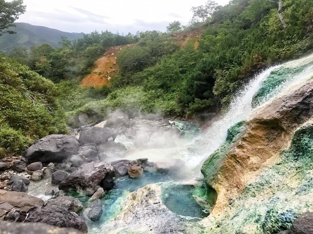
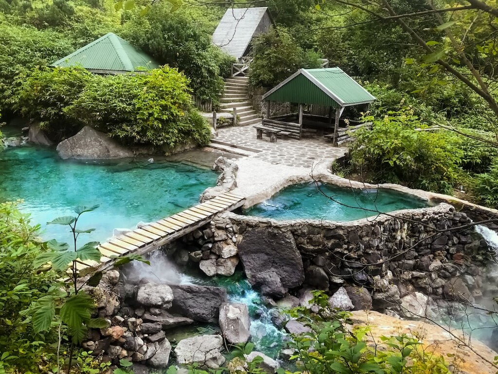
Take a 20-km car ride from Kurilsk to see the fumarole field and mud volcanoes, boiling small lakes the Blue Eyes which generate the sulfuric acid river called the Boiling.
The bathtubs of Baransky volcano on the Boiling river are a stunningly beautiful place, an oasis amidst volcanoes and taiga. You will truly be reborn in a Jacuzzi with water temperature varying from 42°C to 70°C (102-158А) and under a hot waterfall.
If you are lucky with the weather, visiting any place on Iturup Island will leave a trace not only in your soul and memories, but also in beautiful photos and videos. Even if no, pictures in the fog also have ethereal beauty.
When planning a trip to Iturup Island, you should consider getting a border zone permit a few days (a week is better) before your departure date and acquiring a photo and video shooting permit. Russian tourists can get permits to enter the border zone from the Border Division of the Federal Security Service in Yuzhno-Sakhalinsk. Address: 63A, Pobedy Ave., telephone: +7 4242 49 21 04.
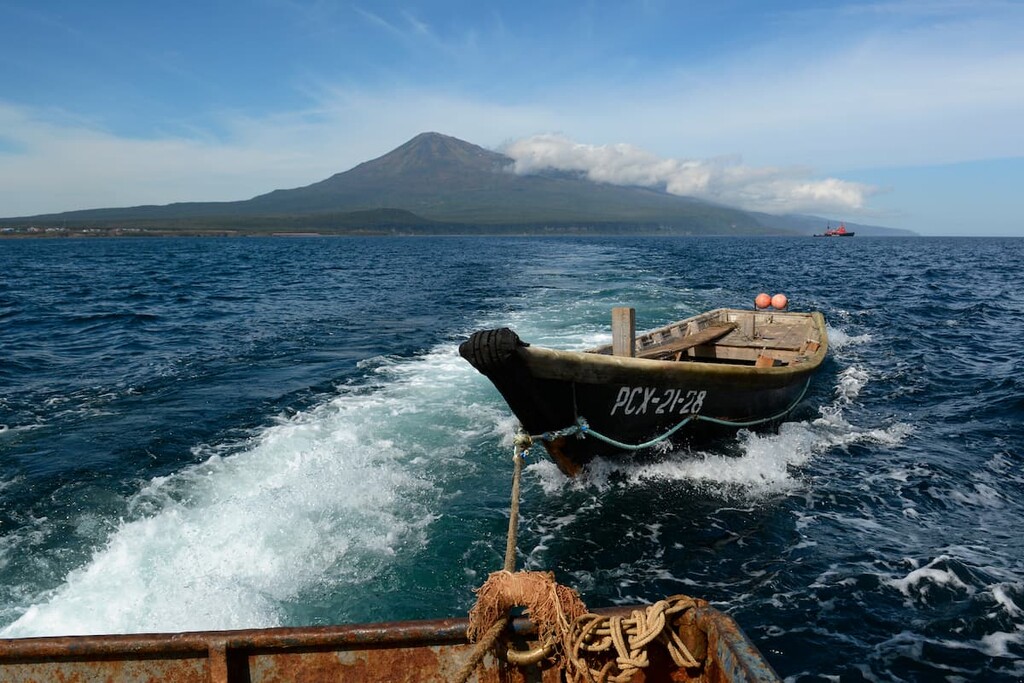
The Iturup Island Sanctuary can be reached by air or by sea. Near the sanctuary is the airport Burevestnik. There is a small pier not far from it on the shore of the Kasatka Bay. You can ride in vakhtovka truck to get to the sanctuary. Vakhtovka is basically a truck tuned into a bus and used to transport people who work on a rotating schedule in regions with severe climate.
If you choose the air route, planes fly to Iturup Island from Khomutovo Airport in Yuzhno-Sakhalinsk (Sakhalin Island).
A longer route is by sea. The port of departure of steamships to Iturup Island in this case is in Korsakov, Sakhalin Island. The destination is the port Kitovy.
Additional contact information for travel to Iturup
You can buy tickets online at rfbus.ru (Russian and English versions are available).
Andrey Korablev korablev@ostrov.sakhalin.ru is the forester of Iturup Island and also a boat carrier.
Forestry telephones +7 42454 42 348 and +7 42454 42 320
Phone number of a vakhtovka truck operator +7 4245 442 005. This van arrives at the plane arrival time and picks up tourists in Kurilsk. The vakhtovka dispatcher should be notified in advance about the intention to make a flight by plane and the need for transportation.
Port Kurilsk. Address: Iturup Island, Kitovoye village, Kitovaya street, telephone: +7 42454 42 099 (supervisor); +7 42454 42 100 (dispatcher)


The highest peak in Ostrovnoy zakaznik is Stokap, at 1,634 m.
Notable peaks in Ostrovnoy zakaznik include Stokap, Stokap (Vershina), Gora Burevestnik, Berutarube and Hitokappu Yama.


