
Scan the QR code and open PeakVisor on your phone
Lagodekhi Nature Reserve was started in 1912 under the Russian empire and is the oldest nature reserve in Georgia. The entire park spans the length of 24,451 hectares (94.41 sq mi) and lies along the northeastern tip of the Georgian in Kakheti along the southeastern section of the greater Caucasus Mountains along the border with Azerbaijan and Dagestan in Russia. Many of the trails go along the Azerbaijan and Russian borders. There are 5 named mountains in Lagodekhi National Park. The highest and the most prominent mountain is Khochaldag.
The park is situated to its North among;
To its northeast;
And to its southeast;
The park rises up abruptly from the Alazani plain to its south and southwest, which spans out into and across Azerbaijan. The park incompasses the;
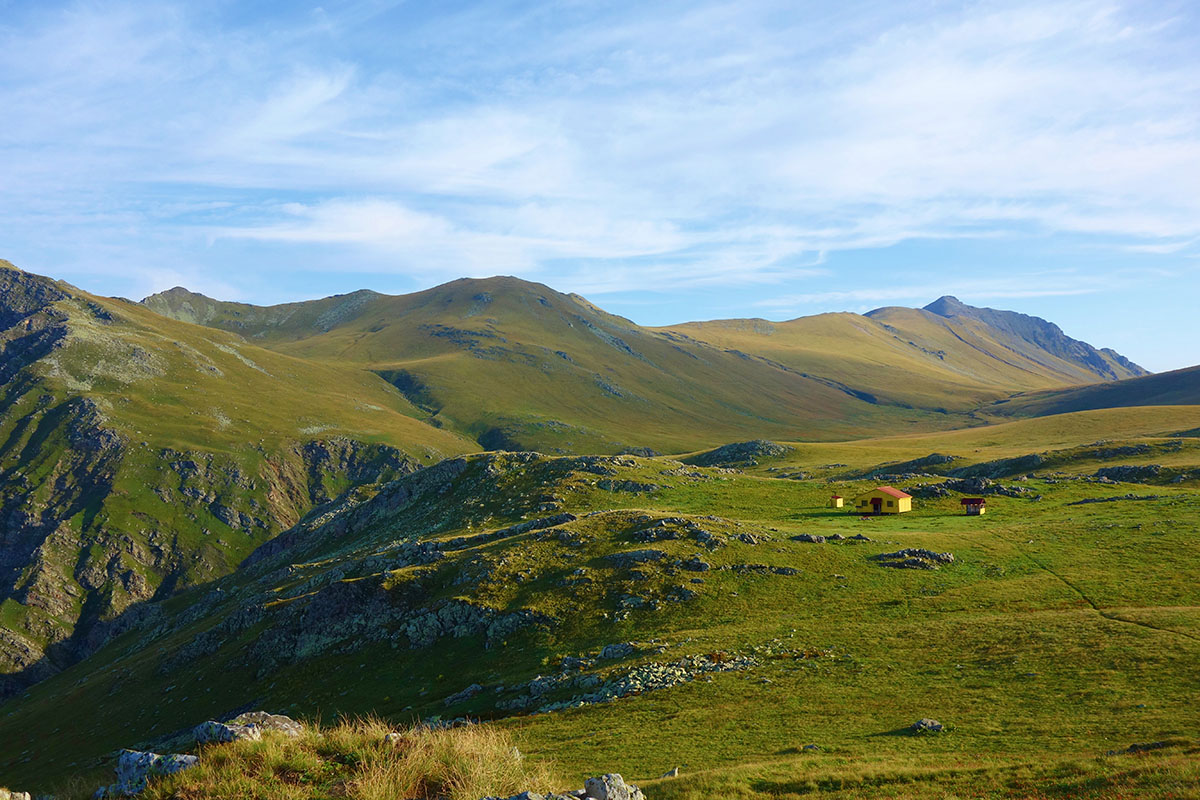
The park boasts sub alpine, mixed forest, and alpine landscapes, making it home to a wide range of flora and fauna in the Caucasus region and a perfect place for hiking. However, Lagodekhi’s landscape is as wide as it is beautiful and can be very rugged at times. As with much of the Greater Caucasus Mountain region, weather is hard to predict as many of the mountains in the area create their own often unpredictable weather patterns. Hikers should be prepared for intense elevation gain and unforecasted thunderstorms, which typically develop later in the day. As is common in Georgia, the switchback system of trail building has not really been well implemented at Lagodkehi, so most of the trail go straight up ridgelines and can be very demanding. Though many trails sections are only 12km in length they often take 5-7 hours to climb based on ability. Additionally, a few trails are even less developed and are incredibly steep so backpackers should take care when heading down valleys and ridgelines with heavy loads as slipping hazards abound, especially after rainfall, on these trails and many of the trails are narrow. Many of the trails in Lagodekhi are also considered equine graded so hikers may run across horseback riders as well.
Black Rock Lake
There are two very notable things hikers should take into consideration when visiting Lagodekhi;
first, you need to register with the park if you are going to trek through Lagodekhi. You need to do this for 2-reasons, first for safety reasons and also so the park can account for its number of visitors each year. There is also a border control station on the Black Rock Lake Trail due to its proximity to Russia so it is very important that hikers bring their passports if they hope to hike up to the lake as they will have to register with the border patrol.
You also will need to register with the park in case you want to stay at any of the tourist shelters or camp in the tourist shelter areas and you will need to pay a fee. Services and fees go as follows;
The exchange rate for Gel to USD averages about 2.5 Gel to 1 USD and the exchange rate for Gel to Euro averages a little over 3 Gel to 1 Euro.
You can reach Lagodekhi by either marshrutka or taxi. The marshrutkas run about 8-10 Gel and the taxis run about 12 Gel per person and are faster, but do not run on a schedule, rather they wait to fill up and then leave, if you are traveling with up to 4 other people this is a great option as you can grab a taxi and leave immediately.
Lagodekhi has 6 notable peaks;
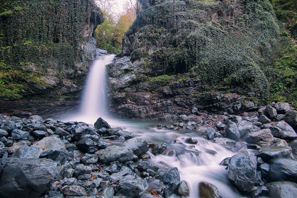
Do not let this relatively short hike fool you. It can be intense, and even impossible during parts of the year. If attempted too early in the season you will have to contend with difficult water crossings due to snow melt that makes the Ninoskhevi River high and very cold, especially as you approach the waterfall.
The waterfall is 40m high at the terminus of the trail. The High Waterfall Hike is an approximately 10km total, in and out of the valley, and has a steady upward climb of about 400-500m. The incline grade of the hike is not challenging.
The majority of the hike is done through the riverbed, making the hike considerably more technical in some places. There are occasionally impromptu river crossing bridges, however these are invariably washed away every year during periods of high snow melt. Therefore, the hike changes slightly each year.
There are some trail groups that are looking into recutting this trail along the valley ridge and building a high swing bridge across the river to make the trail accessible throughout more of the year, but as of 2019 that is still in the development stages.
The blazes for this hike are red and easy to find. If all else fails, follow the river bed.
The entry to this hike is found just past the village of Gurgeniani, west of Lagodekhi, which can be reached by taxi or the helpful local which will take you to the trailhead for a fee, usually around 30 Gel. There is a ranger cabin at the entrance of the hike, but it is recommended that hikers grab a park brochure at the Lagodekhi Park Office in the city of Lagodekhi ahead of time and get information about the hike there as the ranger is not likely to speak English and is mostly there for security.
The Black Grouse Waterfall Hike starts in the same location at the Black Rock Lake Trek at the administrative and information center for the park situated in the village of Lagodekhi. Like the Blakc Rock Lake Trail, the route starts very easily on a wide trail that is a times trafficked by park vehicles. While the Black Grouse Waterfall is smaller than its sister, the Ninoskhevi to the north west, it is a more popular route due to its proximity to Lagodekhi and its ease of access for longer periods of the year.
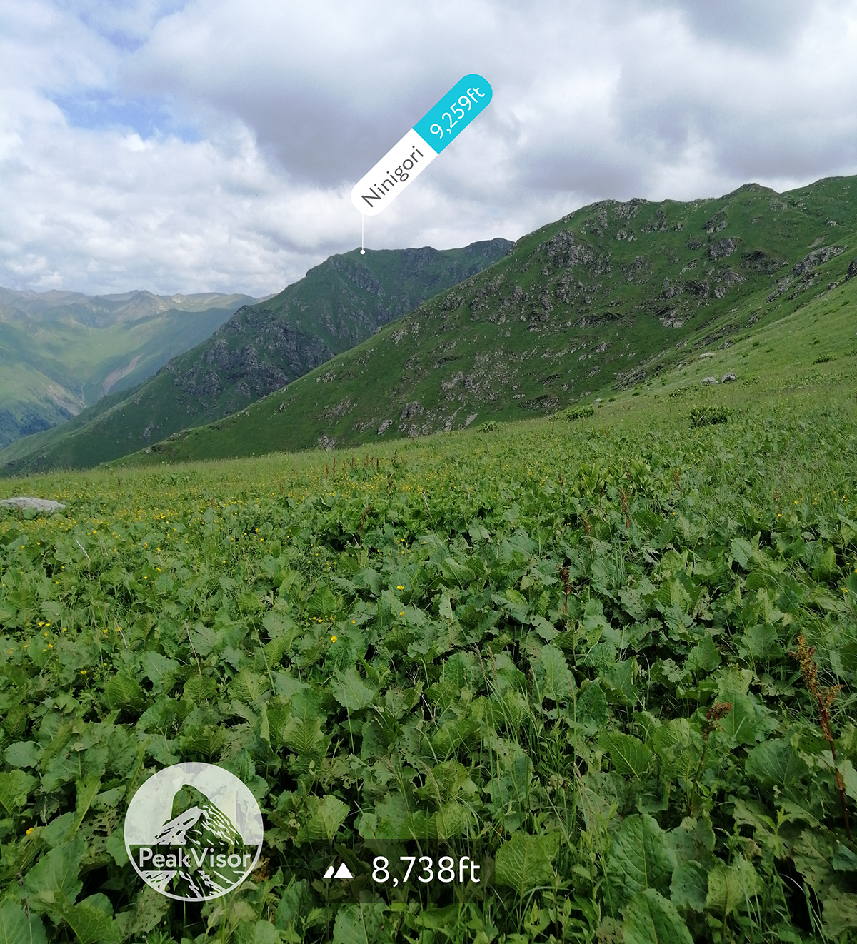
Hikers will see a great deal of flora along this trail including rather rare hornbeam stands, as well as mixed beech stands. The route follows along the left slope of Ninigori mountain crossing the noisy Shromaiskhevi River twice via bridge.
The distance to the waterfall from the information center is 4.75km and the total hike is 9.5km long. It can be done comfortably in 3-5 hours.
The Machi Fortress Hike starts in the village of Matsimi and follows directly along the Azerbaijan border. As such, carrying your passport on you is advisable. A taxi to Matsimi will cost around 20-30 Gel. The route is a favorite for horseback riding in the park.
The route starts at the ranger station and campground and goes Bneli Kheoba (or Dark Gorge) River. The path is rocky, but covered in beautiful moss and is filled with oriental hornbeam and beech trees. You will climb partially up the mountain to the fortress on the Azerbaijan border. The Machi Fortress is a medieval fortress encompassing a small church.
The route to the fortress is 5.25km and 10.5km total. It can be done in 3-4 hours total at a comfortable pace.
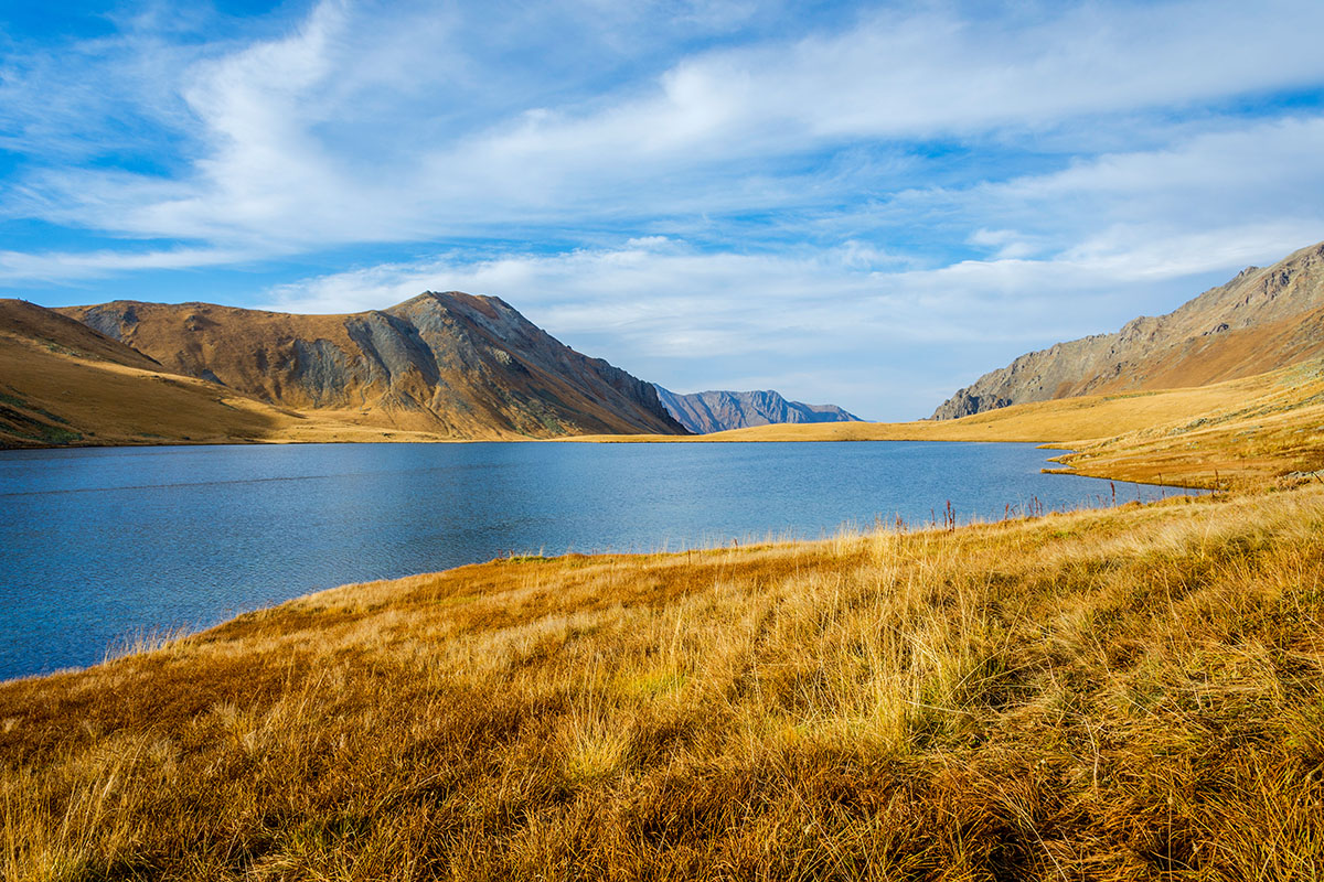
Black Rock Lake serves as part of the natural mountainous border between Georgia and Daghestan in the Russian Federation at 2780m.
You should budget about 3 to 4-days for this trek. While it is a relatively short, as far as treks go, the pathway up is a bit technical and steep in parts, slowing down many trekkers as the trail follow straight up the ridgeline.
It is possible to hike to the lake between late May and early October, but it is most ideal to trek it between the months of June and September, when the weather is warmer and the colors more vibrant, especially on sunny days on top of the mountain. Before June it will not be certain if some of the mountain passes will be passable to get to the lakes so it is advisable to wait until later in the season. There are a number of other smaller alpine lakes on the mountain, however, visiting them is not currently permitted.
Trail development organizations are currently bidding to update both the Black Rock Lake and the High Waterfall day hike so that they are more accessible for longer parts of the year and to a wider array of hikers. This includes maintaining current hiking paths and cutting more switchbacks along the Black Rock Lake trail to make it more feasible to hikers, as well as building a swing bridge across the High Waterfall trail’s Ninoskhevi River so that hikers can hike along the ridgeline, making it more accessible in the spring.
The Black Rock Lake Trail runs close to the border with Azerbaijan (though not along it like the Machi Fortress Trail) and is distinguished as one of the most interesting treks in Georgia due to its views of the Alazani valley and the Caucasus mountains where they meet Azerbaijan and Russia.
Day 1 (14km) - The route starts at the Lagodekhi visitor’s center and starts pleasantly enough through virgin forest with no ascent, but be prepared to ascend endlessly at the 1.5km mark until you hit the Meteo tourist shelter on Mount Kochalo at 2072m, which is a great place to end Day 1 of your hike. The shelter is very comfortable and has mattressed bunk beds and can house 16 people, or you can camp outside. The campsite has a water supply from a nearby spring a few meters away.
There is one water crossing at the Lagodekhiskevi River near the beginning of the hike and it is a toss up whether or not trail groups will have set up a makeshift crossing. Even if there is a crossing set up, any major thunderstorm is likely to wash it away so you may find yourself able to cross with ease on the way up and going through a precarious water crossing on the way down. Take care at this crossing if the water is high.
The first day’s ascent can be broken up into 2-parts. The first part of the ascent has you climbing to the ridgeline and is probably the steepest part of the hike (though the second half is just as tough). At the halfway point of the trail, at 7km in, you will run across a makeshift table and you can see the ridgeline as the trail goes ahead of you.
The second part of the ascent moves you eventually to the ecological border regions between alpine and subalpine. Once you start hitting the high subalpine meadows the trail will level off a bit and get easier. You are very close to the shelter at this point.
Day 2 (14-28km) - You will start walking out of the last of the subalpine areas into the alpine valley. You will have plenty of opportunities to stop and observe Lagodekhi’s wildlife, as well as the Alazani valley in Azerbaijan. You can observe everything from deer, wolves chamois and wild goat, to birds like grouse, Caucasian snowcocks, bearded and various eagles. You are also very likely to see a variety of wildlife scat and paw prints along the trail.
One important, annoying thing to note about the first section of this hike is that the hogweed along the lower sections is tiringly overgrown. Be careful around hogweed as contact with the sap on human skin causes a severe burn when exposed to sunlight. It is not a bad idea to where pants on this hike as it is chilly into the high alpine areas anyway and it will protect your legs from potential burns. There is also hogweed along the Day-1 section of this hike, but it is more prevalent along the higher sections of Day-2.
You will climb about 3 major ridgelines before you hit the border control station as you ascend to the lakes. The first overlooks the Alazani valley and the second to third crosses over into a full high alpine landscape as heads towards the border control station.
You must stop and register with the border control agents, luckily they are very nice and laid back and the process is very simple and doesn’t take much more than 30 minutes. Be sure to have your passport with you or at the very least a copy.
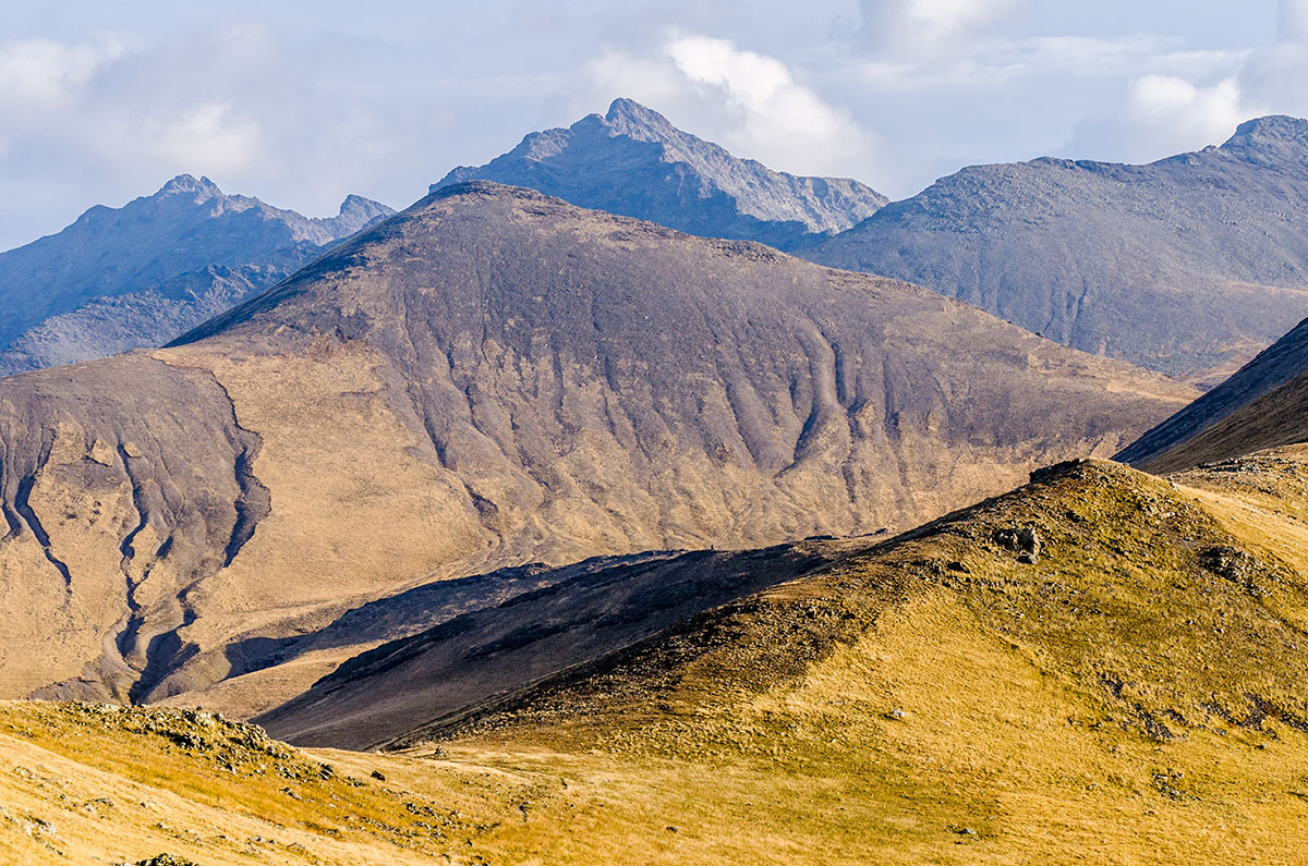
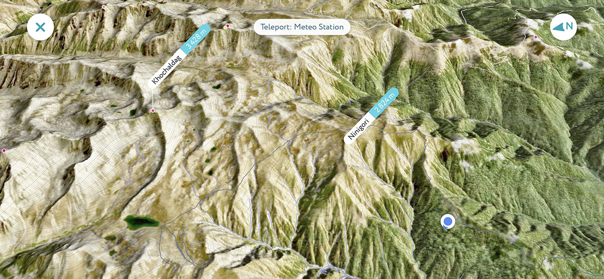
After you leave the station you will head even higher into the high alpine landscape. You will walk along surprisingly damp alpine ecologies as this region of the Caucasus Mountains creates a great deal of rainfall in specifically the high mountain ranges. Visibility at this level will be a toss up and you will either walk through highly visible alpine fields with views of Mount Khochaldag (3428m) along the Russian border, or fields of clouds.
You will first pass through rockier terrain with lots of wildflowers as you cross through quickly dropping valleys below. Then you will descend for a while into high alpine wetlands areas with streams, marshes and a few small alpine lakes, as well as possibly remaining spring avalanche snow drifts in some parts. At one point you will pass by an oddly placed, and seemingly abandoned, partially built shelter.
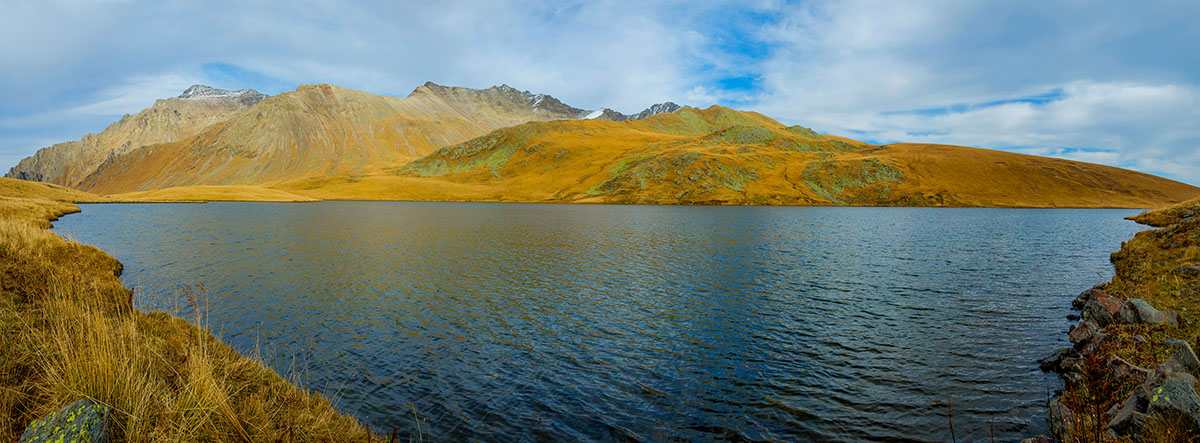
Once you begin approaching the lakes the landscape will expand again and you will cross over one more small hill before heading down into Black Rock Lake, which is surrounded by mountains on each side looking into Russia.
You can continue your trek in one of 2-ways. Either you can do the loop or you can head back to the Meteo tourist shelter. Some people camp at the lakes as well. There is also the Demnidovi’s Bina Tourist Shelter a couple kilometers along the loop of the trail that you can also stay at before heading down the Kudigori Range on Day-3.
From the Lakes you will see;
After you have taken in the waters of Black Rock Lake you can either return to the Meteo Tourist Shelter or go to the Demnidovi’s Bina Tourist Shelter on Day-2. As descending is considerably easier than ascending it will be up to you whether or not you want to make the second half of your trip a 1 or 2 day affair. You can easily go down the mountain in a day however along the same path you took up. If you go back to the Meteo Tourist Shelter the route is already clear.
On day 3, if you head to the Demnidovi’s Bani Tourist Shelter you will turn right at the entrance to the lake instead of left where you came in. This decent along the Kedigori Range is much steeper and less developed that the route going along Khochalo Mountain so care should be taken when taking this route. This route ends along the Black Grouse Waterfall trail and continues to the tourist information center. One good thing about taking the loop is that you will not have to contend with Day-1’s water crossing a second time. However, the upside of returning to the Meteo tourist shelter is that you can treat Day-2 as more of a day hike and take a smaller pack on your trip.
You essentially have 4 options for places to stay during your time in Lagodekhi, camping or a tourist shelter, or a guest house or hotel, depending on what your interests are. For the Black Rock Lake Trail you will obviously either be camping or staying in one of the Tourist shelters on the trail.
There are 5 campsites within the park;
If you are interested in just day hikes then a guest house or hotel may be your most comfortable option. Hotels are less developed in Lagodekhi, though there are a few decent ones, but guest houses in Georgia are typically the preferred option for travelers as many hotels are staffed by low income employees and it shows. Guest houses, on the other hand, are family run and often include either dinner and/or a breakfast option, for 10-15 Gel per meal per person, and overall have a more pleasant atmosphere to them. Booking.com is the most popular way to book you guest house and prices tend to range from 150 Gel per night to as little as 15 Gel per person if you book well ahead of time.
Lagodekhi, like many places in Georgia, is incredibly biodiverse and is home to over 1200 different species of plant life. It was identified by the World Wildlife Fund as;
Lagodekhi National Park encompasses a huge variety of trees with 2 distinct elevation regions between 850m to 1700m, and 1800m to the alpine region at 2300m where the forest line ends and smaller shrubs grow (over 3000m being rocky terrain). These trees at the lower lying regions include;
There are also 121 varieties of plants and wild flowers in both the subalpine and alpine regions, 9 of which are endemic to Georgia and 7 which are native to Kakheti. Some of these include;
The Park is also home to a vast array of animal life such as;
As well as a variety of birds such as;
The park is also home to notable amphibians such as the Caucasian parsley frog.
The man who originally campaigned for the development of a nature reserve in Lagodekhi was the Polish army officer and amateur naturalist Ludwik Młokosiewicz. Młokosiewicz had established a regimental park in Lagodekhi while he was stationed there and he later resigned from the army as a pacifist and was arrested in Tbilisi and deported to Poland in 1861. However, he returned and settled with his family in the area 6-years later in 1987 as the Inspector of Forests for the Signakhi District. Młokosiewicz was a prodigious naturalist as he discovered and shared more than 60 species in the area.
Starting in 1889, Młokosiewicz began campaigning for the region to be protected. Ultimately, Nikolai Ivanovich Kuznetsov, a professor of geobotany at the University of Dorpat (now Tartu) and the Imperial Russian Geographical Society insured that Młokosiewicz advocacy was realized when they successfully campaign for the park’s creation in 1912. This insured that the park would no longer be used for logging. It’s creation set a precedent for nature preservation across Georgia for years to come.
After the Russian revolution poaching and illegal logging became a problem in Lagodekhi, which instigated it be re-declared a strict nature preserve in 1929. The size of Lagodekhi grew in 1935, 1945 and 1970 with the development of regional hunting reserves. However, in 1951, when those hunting reserves were eliminated, Lagodekhi remained fully intact. The same thing happened in 1962–64. Lagodekhi was again at risk of poaching and illegal logging in 1991 when Georgia established its independence from Russia. However, in 1996 Georgia adopted a number of new laws with international standards of nature protection to insure places like Lagodekhi were preserved and safe. In 2003, yet another 6,000 hectares (23 sq mi) were added to the reserve. It was also divided into 2-sections; a large strict reserve and a small managed reserve in the strip of land between the strict reserve and the neighbouring villages, which allowed tourist facilities and an information building to be built. Lagodekhi now has a committed advisory board overseeing its protection.


