
Share

Scan the QR code and open PeakVisor on your phone
Scan the QR code and open PeakVisor on your phone
Qingshuishan Ecological Reserve’s (清水山生態保護區) hilly countryside ripples towards Taiwan’s east coast. Xiaoxingshan (曉星山) is the highest peak at 2,645 meters (8,679 ft) of 14 named mountains. Sanjiaozhuishan (三角錐山) is the most prominent hill at 2,607 meters (8,553 ft).
The steep, stony terrain of Qingshuishan Ecological Reserve lies in Xiulin Township (秀林鄉) of Hualien County (花蓮縣). More specifically, it covers the northeastern region of Taroko National Park (太魯閣國家公園).
A national treasure, Taroko Gorge’s turquoise ravine attracts crowds of visitors as Taiwan’s top scenic site. Qingshuishan’s hills undulate north of the Qingshui River, with an elevation range of 80 meters (262 ft) to 2,645 meters (8,553 ft).

Some other tall hills in Qingshuishan Ecological Reserve are Qingshuidashan (清水大山), Erzishan (二子山), Chaotunshan (朝暾山), and Shashan (砂山).
While nearby Hualien City (花蓮市) enjoys a yearly mean of 75°F (24°C), Qingshuishan’s hills differ according to height. At 1,000 meters (3,280 ft) elevation, the average temperature drops to 62°F (17°C), plummeting further to 54°F (12°C) at 2,000 meters (6,562 ft).
Eastern Taiwan is notorious for heavy rainfall, especially being the first hit by oncoming typhoons and monsoons. Thus, 2,000 mm (79 in) is the yearly average rainfall.

Notable areas surround the Qingshui Ecological Reserve. To the west is Nanhu Ecological Reserve’s (南湖中央尖山群生態保護區) mammoth peaks.
Qilai and Taroko Mountains Ecological Reserve (奇萊、太魯閣山群生態保護區) rests in the south, while the Pacific Ocean lies to the east. Stretching the coastal road from northern Yilan City (宜蘭) to Hualien is the Northeast Coastal Reserve (東北角沿海保護區).
The Central Mountain Range (中央山脈) runs its lofty passage across Qingshuishan Ecological Reserve. The intensity of tectonic pressure created Taiwan's longest and largest massif, and sedimentary rock uplifted to form steep, tall mountains. The Tertiary Period's metamorphic rock comprises Qingshuishan's hills.
Millions of years ago, Qingshuishan's rocky cliffs underwent a lithification process. As Taiwan's land had not yet formed, the hills developed underwater. The layered calcareous sediment on the seabed formed into limestone. Over time, the pressure of new layers transformed the limestone into marble.

Qingshuishan Ecological Reserve’s high mountain terrain affects the region’s vegetation. In the high elevation zones above 2,500 meters (8,202 ft), arrow bamboo (Pseudosasa japonica) thrives in the cold temperate climate.
A flourishing fusion of broadleaf and coniferous arbors dominate the plant life in the mountain forests below 2,500 meters (8,202 ft). Taiwan hemlock, Taiwan two-leaf pine, and Qingshui juniper flood the upper forest belt, while Formosan alder and the Juixiong tree (Lagerstroemia subcostata) feature in the lower environment.
Flowering species such as rhododendron, heather, hypericum, and Taroko spiraea bloom on the lush hillside.

Archaeologists uncovered evidence of prehistoric living at several sites in Taroko National Park. Stone tools, iron pots, and pottery shards remain as artefacts left behind by the earliest inhabitants of Qingshuishan Ecological Reserve.
Fast forward to the present, the Truku tribe is the largest group to inhabit Hualien, Taroko National Park, and Qingshuishan Ecological Reserve. Having previously lived in inland Nantou County (南投縣), the Truku crossed the Central Mountain Range and settled along the Liwu River passage in the 1600s. Over time, the tribe expanded its radius, inhabiting hills and valleys in outlying areas.
The Truku people’s farming and weaving skills are widely admired. They used slash and burn techniques to promote the growth of sweet potatoes, corn, and rice. Their intricate weaving shows in their traditional garments, featuring a tapestry of color.

The most favorable hiking trails and areas in Qingshuishan Ecological Reserve are:
Qingshuishan Ecological Reserve’s highest peak rises above the deep, remote jungle. Encircled by a stream of mountains, Xiaoxingshan lies 30 km (18 mi) away on Heping Forest Road.
Xiaoxingshan Hiking Trail passes lush, dense forests of silver grass on the open road. Reach for the clouds as you begin to ascend Xiaoxingshan, as their soft foamy plumes surround you.
The scenery unfolds the higher you climb. Admire the jagged ridgelines and sharp pinnacles of nearby Beinan Shan (北南山), Erzi Shan, and Qingshuidashan as you clamber to great heights.
A thriving hemlock grove leads you to the summit. You can observe Hualien’s beautiful landscapes of endless hills, emerald valleys, and the nearby Pacific Ocean.
Enter a fantastical world of jade jungles and mountain mist. Fluffy milky clouds are a graceful visitor to the stunning path. Known for its physicality, Qingshuidashan's marbled ridgelines create a challenging climb.
Its proximity to the coast explains the breath of fog every afternoon. Qingshuidashan's plant life is diverse and unique, with many native species named after this hill. Qingshui juniper, hypericum, and barberries are some of the endemic plants.
Qingshuidashan's crumpled rock folds descend south towards the Liwu River, the belly of Taroko National Park. To the east, the mountain spans towards the coast, where the high cliffs suddenly drop vertically into the Pacific Ocean.
Closer to the accessible, undulating hillside of Qingshuishan Ecological Reserve is the more terrain-friendly Liwushan Hiking Trail. Situated near the Liwu River Mouth, Liwushan (立霧山) offers maximised views of Taroko’s marble gorges.
Liwushan’s ecology is most astounding. Its dark and damp forest teems with luscious broadleaf trees and shrubberies. The peak rises from the nearby ocean, offering hikers unrivalled views of the cerulean sea’s tidal dance below.
Known for its gentle path to the summit, Liwushan attracts many eager hikers for its beautiful outlook. You can gaze down at the marble cliffs jutting into the Pacific Ocean. The Liwu River’s path trails westwards like a sapphire snake, while a rippling mountain scene stretches out inland.
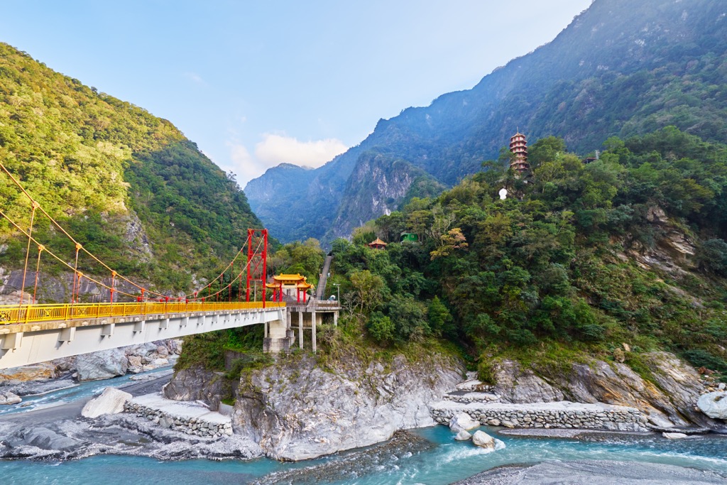
For sublime views over Taroko Gorge, head to the Eternal Spring Shrine. Every eastern Taiwan guidebook dons the iconic picture of the majestic Eternal Spring Shrine perched above a waterfall.
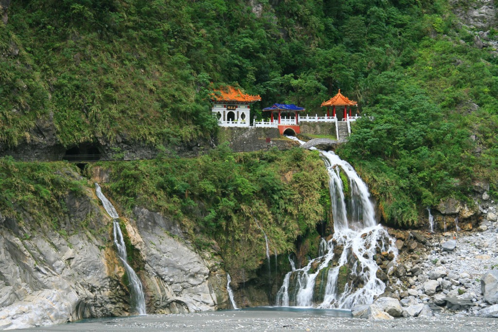
The short 2 km (1.2 mi) course journeys through lush foliage with the turquoise Liwu River never too far out of sight. Take the stairway past the legendary temple that rises sharply to meet pristine outlooks.
From above, you can gaze over the lavish greenery covering the deep marble gorges. The Liwu River looks like a cerulean ribbon weaving between the rockwork.
For a chance to inspect Taroko’s signature monochrome marble cliffs, take a stroll on the 1.4 km (0.9 mi) Swallows Grotto Trail. Enter the dark and dim caves where swallows flock for nesting.
Observe the punctured pockets on the rockface, weathered from millions of years of wind and water erosion. While the swirling marble cliffs are astounding, the star feature is the sparkling Liwu Stream flowing through the narrow, sheer gorges.

One of Taiwan’s most scenic bays, Qingshui Cliff (清水斷崖), is beautiful and fascinating. At low tide, wander along the strip of pebble beach and dip your feet into the inviting aquamarine sea. Admire the intimidating size of the high rock walls facing the endless ocean.
A blue sea blanket raps against the cliff at high tide, knocking its arrival with every new wave. Hovering 58 meters (190 ft) above the ocean, Qingshui Cliff protrudes above the Pacific Ocean.
The wispy afternoon clouds add a mesmerizing touch to the scene. Take in the surrounding beauty of overgrown greenery, heavenly blue waters, and the dominating presence of the marble cliffs.

Hualien is the closest city to Qingshuishan Ecological Reserve, a suitable base for exploring the mountainous wilderness. Tianxing (天祥) a settlement in Taroko National Park, is a convenient stay for those wanting a more authentic experience with the locals.
Taiwan's precious gem, Hualien is a paradise on the remote east coast. Popular amongst avid travellers wishing to discover Taroko's beauty, Hualien is a hiker's haven with many scenic attractions to explore.
Meilunshan Park offers something for everyone. Mountain trails, forest bathing, and superb views of Hualien are some of its most enjoyable features. People of all ages and abilities can appreciate the sumptuous greenery of the stunning outdoors.
Another place to admire Hualien from a height is at Pine Garden. Dripping in history as the sending-off venue for kamikaze pilots during the Second World War, Pine Garden's stately house is a magnet for intrigued visitors. Its well-manicured lawns look out onto the city and the expansive ocean.

Delight your senses with a visit to Dongdamen Night Market. Known as eastern Taiwan's most vibrant and largest night market, Dongdamen will not disappoint. Over 400 vendors sell the most flavorful and fascinating foods. Try the tasty green onion pancakes, fried wild boar, or garlic clams. Dare to sample the stinky tofu, pigs' blood cake, and horned snails!
Situated in the heart of Taroko National Park is the Truku village of Tianxiang. Many villagers operate homestays, allowing visitors to lodge with the locals for a first-hand encounter of the Truku’s lifestyle and customs.
The ancient settlement of Buluowan is a prehistoric site. Archaeologists found evidence of human activity in old cooking tools and broken ceramics. The Truku people show pride in their culture and history by displaying and selling Truku traditional art. Wander the Taroko Handicrafts Exhibition Room, where you can witness the Truku speedily weaving baskets of rattan and bamboo.

For a slice of picturesque paradise, head to Xiangde Temple swathed in fertile foliage. The only manufactured landmark in sight, take pleasure in admiring the scenic surroundings of forested hills and valleys. Find peace and solace at this spiritual site, made even more touching by the bountiful nature.
Finally, venture to the Tunnel of Nine Turns Trail to witness Taroko’s striking rock folds in the graystone cliffs. The Liwu River is so close you can nearly touch it, but its bubbling and flowing passage fill the silence. Yet again, be amazed at the glorious beauty of Taroko National Park.
From Taipei City, take the local express train (TRA) to either Xincheng or Hualien. The Taroko Trip Bus 310 departs from Xincheng and Hualien train stations and transports passengers to Tianxiang, the gateway to Qingshuishan Ecological Reserve.
Visitors can hire a car or scooter from Hualien. It is a 42 km (26 mi) drive to Qingshuishan Ecological Reserve.

Explore Qingshuishan Ecological Reserve with the PeakVisor 3D Map and identify its summits.


