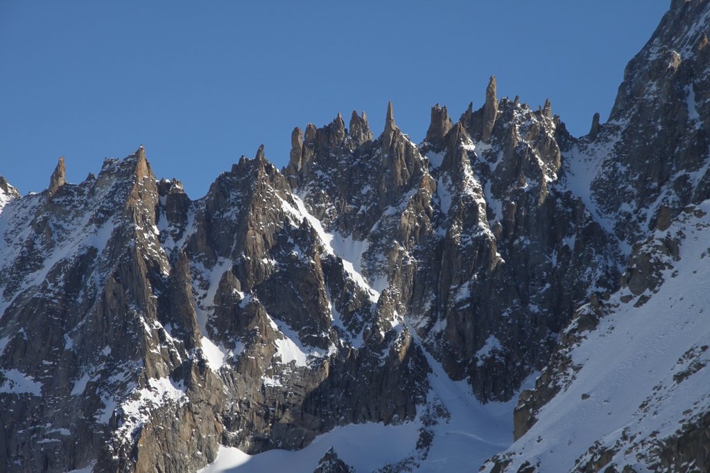
Les Périades (highest point: 3,549 metres (11,644 ft)) is a sharp and heavily-pinnacled mountain ridge, stretching for over 1,500 metres (0.93 mi) in the Mont Blanc massif in Haute-Savoie, France. It runs in a southerly direction from the Col du Tacul to the Col du Mont Mallet. Its highest point is Pointe Cupelin (3,549 metres (11,644 ft))Principal points along th crest of Les Périades, from south to north:
Pointe Auguste Cupelin - 3549 m
Pointe 3517 m
Pointe de la Fenêtre - 3507 m
Pointe de Sisyphe - 3460 m
Pointe Alfred Simond 3457 m
Pointe Nini - 3455 m
Pointe Francois Simond - 3493 m
Pointe des Périades (or Pointe Paul Perret) - 3503 mLes Périades are divided into three parts by the Brèche Puiseux (or Brèche Supérieure des Périades) and by the Brèche des Périades.
A bivouac hut (known as the "Bivouac Paul Chevalier alle Périades") was installed near Pointe de Sisyphe in 1928 at a height of 3,455 metres (11,335 ft). It eventually became the property of the French Alpine Club, and was renovated in 1996. The site collapsed in 2019 during the summer heatwave which caused previously frozen ground to become unstable. It was replaced in 2020, following a public fund-raising campaign, and can accommodate three or four people.:
The nearest mountain hut is Bivouac des Périades located 718m/2 355ft SSW of the summit.
We use GPS information embedded into the photo when it is available.
3D mountains overlay
Adjust mountain panorama to perfectly match your photos because recorded by camera photo position might be imprecise.
Move tool
Rotate tool
Zoom
More customization
Choose which peak labels should make into the final photo and what photo title should be.
Next
Photo Location
Satellitte
Flat map
Relief map
Latitude
Longitude
Altitude
OR
Latitude
°'''
Longitude
°'''
Apply
Register Peak
Peak Name
Latitude
Longitude
Altitude
Register
Teleport
PeakVisor
This 3D model of Sagarmatha National Park in Nepal was made using the PeakVisor app topographic data. The mobile app features higher precision models worldwide, more topographic details, and works offline. Download PeakVisor maps today.
Download OBJ model
PeakVisor
The download should start shortly. If you find it useful please consider supporting the PeakVisor app.
PeakVisor for iOS and Android
Be a superhero of outdoor navigation with state-of-the-art 3D maps and mountain identification in the palm of your hand!