
Share

Scan the QR code and open PeakVisor on your phone
Scan the QR code and open PeakVisor on your phone
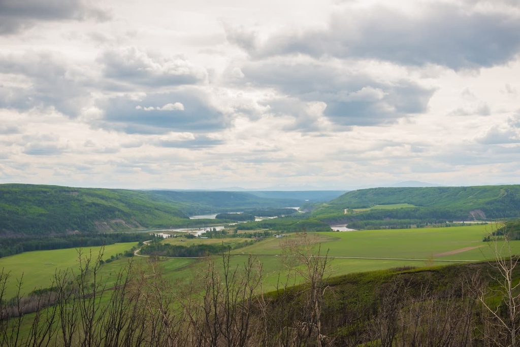
Butler Ridge Provincial Park is located on the north shore of the Peace Reach of Williston Lake in northeastern British Columbia, Canada. Despite encompassing only 60 square kilometers (23 square miles) of land, the only peak in the park is the 15 km (9 mi) long Butler Ridge. The peak has an elevation of 1,638m (5,374 ft) and a prominence of 615 m (2,018 ft).
Butler Ridge Provincial Park is located at the southeast end of the Muskwa Ranges of the northern Rockies, in British Columbia, Canada. Overlooking the Peach Reach of Williston Lake, the 60 square kilometer (23 square mile) park is home to one peak: Butler Ridge.
The community of Hudson’s Hope is located to the southwest of Butler Ridge Provincial Park. Highway 29 is the primary road towards Butler Ridge Provincial Park; however, the final 20 km (12 mi) are on 12 Mile Road. The park has a boat launch for the Peace Reach, which is part of British Columbia’s largest artificial lake.
There are also several other provincial parks near Butler Ridge Provincial Park. In particular, Pine Le Moray and Gwillim Lake Provincial Park are located to the south of Butler Ridge in the Hart Ranges while Graham-Laurier Provincial Park is located to the northwest.
Butler Ridge is part of the Peace Foothills of the Far Northern Rockies, which started forming about 380 million years ago as sediment settled on the bottom of a shallow sea along the ancient North American coastline. This marine sediment accumulated during the Paleozoic era. Additionally, during the Cretaceous period of the Mesozoic era, rivers added layers of continental sediment to these marine sediments.
About 75 million years ago, tectonic plates under the Pacific Ocean collided with the west coast of North America. Over the next 40 million years, this ancient coastline cracked and buckled, ultimately stacking the layers of Paleozoic and Cretaceous rocks.
As part of the foothills of the Far Northern Rockies, Butler Ridge formed as part of the final pushes of this tectonic collision. The mountains of the northern Rockies are typically composed of Paleozoic limestone and Cretaceous sandstones, though the sandstones have mostly been eroded away, forming the major valleys in the region.
However, as the force of the collision dissipated through the mountain building process, the foothills tend to only be layers of Cretaceous sandstones and shales that were pushed up and stacked. Butler Ridge is typical of foothills formation in the region, with a gentle west slope that rises to the peak and an abrupt drop to the east side. As such, the rows of foothills in this area often look like shingles on a roof.
The Muskwa Ranges and Peace Foothills were covered with glaciers and ice sheets during the Pleistocene that were often over a kilometer thick. The glaciers rounded the top of Butler Ridge and subsequently deposited the eroded debris across the surrounding valleys and foothills.
The glaciers melted from Butler Ridge around 12,000 years ago, at which time vegetation slowly began to cover the landscape. Over the thousands of years since the glaciers melted, the vegetation grew and changed to form the two primary ecozones that we see in the park today.
The two primary ecozones of the park are the subalpine zone, which is dominated by Engelmann spruce and subalpine fir, and the Altai fescue and sedge covered alpine zone.
Located at only 1,638 m (5,374 ft) of elevation, the alpine zone in the park doesn't receive the full force of winter storms like those of the Muskwa Ranges to the west. As a result, the ridge has extensive heath, meadows, and grassland.
The heath along Butler Ridge is mainly the hardy Altai fescue and sedges. Heather and dwarf shrubs are present along the alpine trail, with krummholz growing on the lee side of the ridge and any rocky outcroppings in the area. The alpine gradually transitions to the subalpine where stands of trees grow closer together, until the slopes are covered with dense subalpine fir and Engelmann spruce forests.
Engelmann spruce tends to live longer than subalpine fir, so the canopy is usually dominated by spruce with abundant fir in the understory. However, subalpine fir tends to dominate the upper elevations and along the tree line.
The upper elevations of the park provide important habitat for caribou and stone sheep, and the stone sheep may be spotted in the canyon near the boat launch in the park. Moose and elk inhabit the lower elevations throughout the year, as do deer, golden eagles, and numerous waterfowl and shorebirds.
The southern end of Butler Ridge and the provincial park are along the northern shores of the Peace Reach of Williston Lake. The lake is home to abundant rainbow trout and kokanee, as well as bears and eagles.
As the ice sheet melted away at the end of the Pleistocene, the eastern slopes and the foothills of what is now Butler Ridge Provincial Park were among the first areas of the region to be ice-free. In fact, to the east of Butler Ridge Provincial Park, the Charlie Lake Cave has archaeological evidence of people that inhabited the region as far back as 10,500 years ago.
The caves, which are only several kilometers to the north of Fort St. John, have evidence of migrating bison hunters, as well as artifacts that are considered to be the oldest evidence of ritual acts in what is now Canada. The oldest artefacts uncovered at the site are representative of the historic megafauna that roamed ancient Canada.
In 1793, Alexander Mackenzie made contact with the Dane-zaa for the first time. The Dane-zaa have inhabited the area in and around Butler Ridge Provincial Park for many generations. Oral history of the Dane-zaa recounts how a major conflict ended in the late eighteenth century or the early nineteenth century between the Dane-zaa and the Cree.
The conflict began as the Cree moved west with the expansion of the fur trade. They often acted as intermediaries between traders and other First Nations. However, the migrating Cree were also expanding their territory and influence, and as such they came into conflict with the First Nations currently inhabiting the land around what is now Butler Ridge Provincial Park. The Cree conflict with the Dane-zaa ended with a ceremony along the Peace River.
The ceremony along the river decided how the land would be divided between the nations. The Cree would maintain the territory to the south of the Peace River while the Dane-zaa would maintain the land to the north of the Peace River.
Butler Ridge Provincial Park was established in June of 2000. It is named after General Sir WF Butler, who was an officer in the British Army during the Red River Rebellion in the late 1860s. Butler also made a scouting trip into the Rocky Mountains on behalf of the Canadian Government in the late nineteenth century.
His travels took him to a number of places in the region, including to what is now Fort St. John and Hudson’s Hope. He also paddled the Peace River by canoe and he wrote a report that contributed to the formation of the Northwest Mounted Police within what is now northern British Columbia.
Nowadays, Butler Ridge Provincial Park is a remote, yet exciting place to visit if you’re looking to hike, fish, hunt, horseback ridge, or simply just marvel at the beauty of the region’s mountainscapes.
Butler Ridge Provincial Park is small and remote; however, there are a couple of notable features in the park.
The main feature of the park is the Butler Ridge Trail. The trail leading to the ridge is about 7 km (4.2 mi) long, It goes straight up the side of the ridge and has a total elevation gain around 750 m (2,460 ft).
The trail is steep and there are few switchbacks; however, there are lovely views from the summit as well as the opportunity to hike the 15 km (9 mi) ridge. Making it to the ridge gets you views to the east through the Peace Foothills, west toward the Muskwa Ranges of the northern Rockies, and south to the Peace Arm of Williston Lake and the Hart Ranges.
The other notable feature of Butler Ridge Provincial Park is the boat launch into the Peace Arm of Williston Lake. Williston Lake is the largest manmade lake in British Columbia, and it has rainbow trout and kokanee to catch.
Located alongside the remote Muskwa Ranges of the northern Rockies, Butler Ridge Provincial Park has only small towns and cities nearby; however, there are a number of great communities to visit in the area. The following are some of the primary municipalities near Butler Ridge Provincial Park:
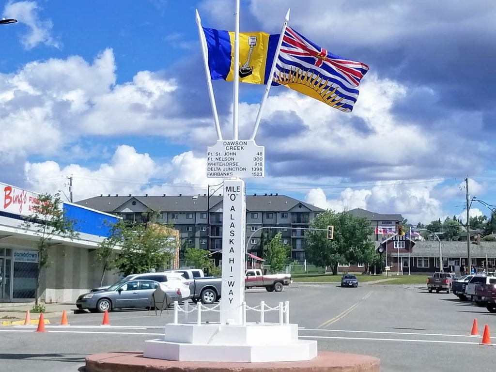
Butler Ridge Provincial Park is located 120 km (72 mi) to the west of Fort St. John, the most populous city in the Peace River Regional District. Located at Mile 47 of the Alaska Highway, Fort St. John is the largest city between Dawson Creek, British Columbia and Delta Junction, Alaska.
Fort St. John is among the oldest European settlements in British Columbia, having been established in 1794 as a trading post shortly after Alexander Mackenzie first travelled through the region.
While in Fort St. John, some of the trails and attractions to look for are the Charlie Lake Caves where you can see where cultures left evidence of their passing from over 10,000 years ago. There are also many trails near the city, such as the Willow Loop, Cactus Trails, and the Cecil Lake Highway Trail Loop. From the trails there is a vast northern wilderness to explore.
Located about 200 km (120 mi) to the southeast of Butler Ridge Provincial Park, Dawson Creek was founded in the early twentieth century. It is located at Mile 0 of the Alaska Highway, making the city a gateway to Alaska and the northern wilderness of Canada.
The region surrounding Dawson Creek has beautiful wilderness areas that are great for hiking, skiing, and OHV use. In addition to wilderness access, the city has an art gallery, a historical village, a museum, as well as annual fall fairs and a rodeo.
Some of the popular hikes around the city of Dawson Creek are the casual 1.8 km (1 mi) Leoppky Park Trail and the 9.7 km (5.8 mi) Dawson Creek Trail. There is also a moderate 7.4 km (4.4 mi) hike along the Rim Rocks Trail.
Situated about 275 km (165 mi) to the southwest of Butler Ridge Provincial Park, the town of Mackenzie is located on the west side of the Hart Ranges off Highway 39, along the shore of Williston Lake. Mackenzie hosts dog sledding, cross country skiing, and snowmobiling competitions, and is a great place for winter-loving outdoor enthusiasts.
In addition to the 32 km (19 mi) of cross-country ski trails the community keeps groomed throughout the winter, there are many trails nearby that are worth hiking if you’re in the area. Some of the recommended trails are the Morfee Lake Trails, Cut Thumb Falls, and the Kimta Creek Trail.
Explore Butler Ridge Provincial Park with the PeakVisor 3D Map and identify its summits.

