
What is the highest mountain in the world? It looks like an evident pageant contest question. Don’t jump at your conclusions, your geography teacher might have not told you the whole truth. We’ve stumbled at some baffling pictures on the Internet and decided to look into the matter.
You might remember trigonometric tasks back from school days when you were asked to measure how tall a building is, or a mountain is without succumbing to almighty Google and using just your power of calculation, like here.
Here comes a question, or two. Firstly, how do you measure your angle accurately because even a 1-degree difference can matter? Secondly, how do you accurately measure the distance from the building, especially if there is a flowerbed by it? I bet applying trigonometry to measuring a mountain elevation is even more challenging.
Trigonometric Measurements: the Classics
Historically, people would just measure the distance between two points on the ground and then measure the angles between the top of the mountain and each point. Then there were some hundreds of minor adjustments introduced, and voila this is how you made your calculus in the 19th century and back. But was it really the elevation that was measured or was that prominence?
There is one more concern with trigonometric principles. What if you have to measure something imperfect in shape when the shadow cast by your object is hardly detectable? For instance, not a majestic rigid Matterhorn but Mont Blanc, for which identifying the summit is no mean feat?
GPS and Real-Time Kinematic: the Art Nouveau of Measuring
Here digital revolution comes to your rescue. Let’s be honest, modern GPS and RTK (Real Time Kinematic) systems still rely on geometric formulas and surveying techniques that haven't changed all that much since the 1800s.
You are welcome to plant your GPS receiver on top of any mountain (and use radio signals received from 4 or more GPS satellites to ensure sufficient precision of measurement) and discover the elevation of the receiver relative to the satellite, which sits at a known distance from the centre of the Earth, which in its turn is spheroid (meaning not absolutely round but kind of a ‘tangerine’ shape). Will that measurement be enough? No, you still have to identify what your reference point is whether it is sea level, mean sea level, the foot of the mountain, the place where you feel the mountain starts etc.
What is your reference zero point?
Measuring heights is a tricky business, with the technological advancements and discoveries you feel that the rules of the game are changed too often. You have a sensation like when you were sitting in a physics class and your teacher asked a question: “If you shoot a gun on a train moving at the speed of 80mph, will the bullet move faster or slower?” You sit and ponder: “Faster than if you were standing on the ground? What is the direction of the shot: is it to the head or the back of the train etc?” You are occupied for the rest of the lesson, the teacher is happy kids are doing something, their brains being kept away from mischief, life goes on.
Jokes aside, here are some questions, the answers to which will change one’s perception of the height of mountains. Where do you set your reference point?
- From where you stand (the classical trigonometric positioning) – that is prominence, not the elevation/height, because you are most probably standing at key col. So, prominence is roughly the least vertical drop to be covered to get from the summit to any other higher terrain. The lowest point of the vertical drop is called the Key Col.
- From the sea level – what if there is no sea for you to see in a hundred miles? Well, even if you can identify the sea, the sea levels differ by as much as 50 meters, depending on the tides, waves, gravitational pull, that is why we have the so-called average/mean sea level. Height above mean sea level (AMSL) is the elevation (on the ground) or altitude (in the air) of an object, relative to the average sea level datum or geoid. The most accurate GPS-based measurements now assumably have an error margin of a foot or two for objects higher than 7km.
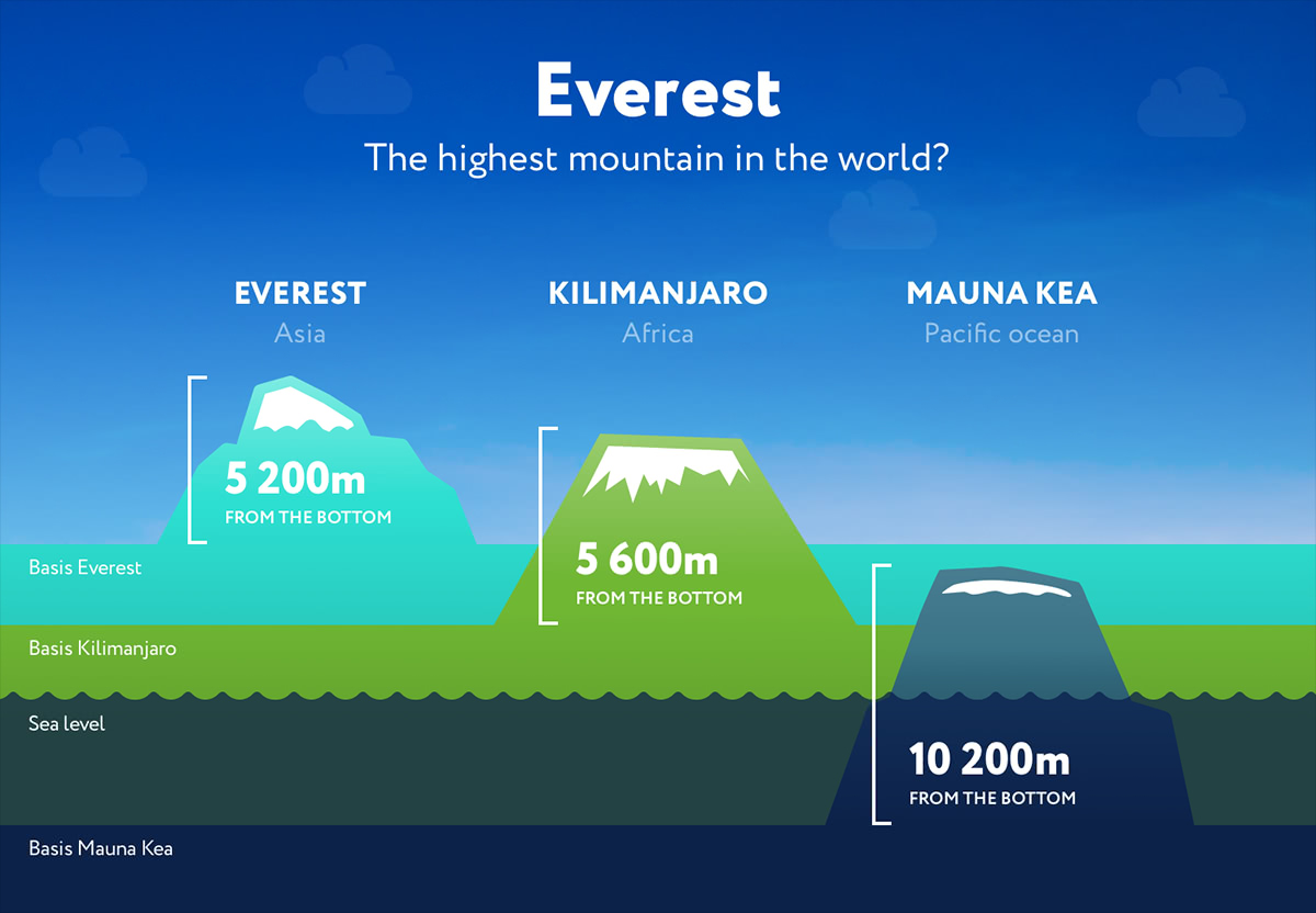
- From the foot/basis of the mountain – what if you are in a mountain range and looking not at a single isolated mountain like Uluru in Australia for example, but at K2 or Anapurna, there are too many feet to stamp! But this might be the most accurate approach to measuring the height of the mountain. Now, how to identify the foot? Some mountains are the so-called fold, some are block and some are so deeply eroded that you may fail to locate the start of the mountain and the end of the valley. That is probably the question to be addressed to geologists who can identify the folds of rocks that make up a mountain and biota specific for mountains only.
- From the ocean bottom? Welcome to the Mariana Trench of 10,994m deep, which is also dubbed the bottom of the world or Sirena Deep discovered merely 20 years ago (1997) that is 10,732m and just imagine how many more deep reference points will come up once humanity have researched the rest 95% of the world ocean bottom!
If you wish to have a closer look at physics lying in the basis of many measuring principles of earth’s features, have a look at on the sea level measurements and why Mauna Kea in a way higher than Everest! It gives you a rough outlook at what a sea level is and how it influences our measurements based on the ‘average sea level’ term.
And how do you measure heights? Oh, and do you take the icecap of the mountain into account? Or should it be rocks only?